
Website Search
Search Website
Displaying results 1 - 25 of 115

A 1,200-square-foot gallery that features a wide variety of art by local and regional artists. A participating gallery at Gallery Hop.
The Kentucky Room's collections contain Lexington's residential directories going back over 200 years, and are some of the most useful resources for researchers looking for family information, neighborhood histories, and house histories.
Mariam gives a brief history of the public schools in Lexington and Fayette County.
Jamie tells an abridged history of Russell’s Cave, Fayette County’s largest cave.
Mariam and Wayne discuss the history of Lexington & Fayette County’s merged governments, one of only fifteen merged city-county governments in the United States.
The Bath County Memorial Library was founded in 1949 by the Owingsville Women’s Club, and opened in January, 1950. It expanded into a bookmobile in 1953, and in 1963 moved into the old Farmer’s Bank Building at 24 W. Main St.
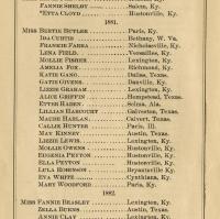
The library has a variety of directories and yearbooks with local information. In the library's current digital collection, there is a selection of residential and street directories, yearbooks, school directories, and organizational directories. These are all fully word-searchable.
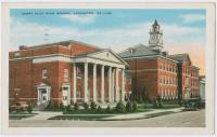
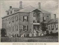
Lexington's school system dates back to the city charter of 1831, and it first school opened in 1834.
Until 1974, Lexington and Fayette County had two separate governing bodies.

A 31-foot gallery wall that features a wide variety of art by local and regional artists.
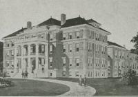
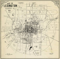
Fayette County's buildings contain a great deal of history about the region and its inhabitants.
Digital Archives - Collection

In the summer of 2019, the Lexington History Museum exhibited a 20th anniversary timeline and historical materials exhibit titled, Our Fair City: the 1999 Lexington Fairness Ordinance.
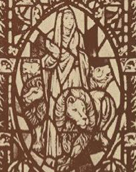
Fayette County churches contain some of the earliest records and information preserved about central Kentucky history. The digital archive contents include church ledgers, minutes, directories, and informational brochures.

A gallery featuring photography by the Tates Creek Photography Club.
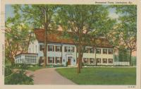
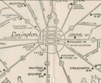
The Fayette County Postcard collection contains images of well-known sites in Central Kentucky, such as Keeneland, Transylvania University, Ashland, and many others.
The Lexington-Fayette County Health Department had its earliest form almost as long as the city itself has existed, when the newly formed city of Lexington would appoint a local physician to investigate reports of certain diseases for qu
While the focus of content in the digital archive is Fayette County, many other counties are represented. This list is in alphabetical order by county name for non-Fayette County content.
Anderson County
Fayette County, Kentucky, has changed enormously since it was created in 1792. This collection contains government documents for the city of Lexington, for Fayette County, and for the merged Lexington-Fayette Urban County Government, as well as funeral notices, club directories, scrapbooks, image collections and a history of Lexington Public Library.
See what's currently on display at our art galleries.
The Lexington Public Library’s Digital Archives provide open access to researchers and students to learn more about the rich history of Lexington and Fayette County. It contains a fraction of the Library’s physical holdings, which are housed and available for reference in the Kentucky Room at the Central Library. New material is being digitized and added constantly, so there's always something new to find.
The archives have a simple keyword search, and it is possible to browse the collections by subject, area, or decade. The Lexington Public Library actively reviews and labels materials in our archives with statements that indicate how you may reuse the images, and what sort of permission, if any, you need to do so. Please check the information for each image to determine its legal status.
The Undesign the Redline project unearths the deep and systemic history of structural racism and inequality in the United States. This interactive exhibit explores policies like Redlining, their implications for today, and what we can do to undesign them.
The exhibit was created by social impact design studio designing the WE and has been invited to dozens of cities across the country. A local advisory group has helped to produce local history and stories about Redlining in Lexington.
The Central Kentucky Cemeteries Maps are powered by Google Maps. Counties include: Fayette, Bourbon, Clark, Garrard, Harrison, Jessamine, Lincoln, Madison, Mercer, Montgomery, Nicholas, Powell, Scott, and Woodford.
Thanks for your interest in joining the Lexington Public Library! Your library card is the key to checking out books, downloading audiobooks, taking online classes, and much more. Please check here to find out if you qualify for a library card and how to apply.
Discover unique resources in our Digital Archives that tell the story of Fayette County. Visit cemeteries throughout Central Kentucky using our cemetery maps. Contact our resident experts in the Central Library's Kentucky Room with questions.
Check here for your school's list of summer assignments.


